Record # 927 -- Image Metadata
Historical photograph record:
| Record ID | 927 |
| Photographer | Pole Evans |
| Digital image number | PE_TF04_026 |
| Date of photograph | 1919/--/10 |
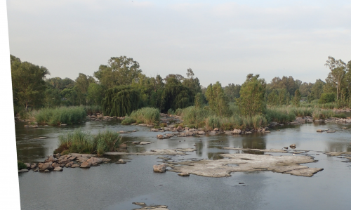
| Original caption | Vaal River. Parys. Phragnubes salise. Acacua horrida |
| Location description | Parys |
| QDS | 2627CD |
| Coordinates | -26.899520635409 27.445064663887 |
| Attribution | rephotosa.adu.org.za - UCT & SANBI |
Repeat photograph record:
| Repeat id | 166 |
| Record id | 927 |
| Digital image number | PE_TF04_026 |
| Photographer | de Speville, Lisa |
| Day | 10 |
| Month | 1 |
| Year | 2018 |
| Time period | 06:15 |
| Height camera (cm) | 500 |
| Height camera quality | ESTIMATED |
| Location description | I took this photo from the main bridge that crosses the Vaal River (on the R53). I also tried versions from below the bridge, standing on the highest rocks I could find. The current bridge is too high; being at water level is way too low. There is evidence of past bridges - discarded cement, drillings in rocks - below the current bridge. My assumption is that Pole-Evans was standing on a bridge that was perhaps 3m above the water level; lower than the current bridge. I lay on my belly to take this photo. My angle is still off but this was my closest repeat for this one thus far. |
| Location cairn | NO |
| Landscape changes | Significantly more vegetation growth - loads of blue gum trees on the rocky islands in the river. There is also considerably more vegetation growth on the banks. The hills in Pole-Evans' photo are not currently visible because of the vegetation. If you drive a little further along the road you can catch a glimpse of them. These hills are part of the Vredefort Dome area. |
| Weather conditions | Hot summer weather. |
| Additional notes | Water level is key in this photo. The level of water in the Vaal River as it runs through Parys is controlled by water released from the Vaal Dam (and Barrage in Vanderbijl Park). The catchment of the Vaal River is in the Ermelo area (not Johannesburg) so high levels only really come about when there have been good rains in the catchment. After 60-150 cumec in the week between Christmas and New Year, the water dropped and remained at about 12-15 cumec throughout January 2018 - we don't always see it this low even in winter. There are farms an industries downstream that are dependant on the water supply from the Vaal - so water releases are critical. Back in Pole-Evans' day, the water level would have been dependant on rainfall as the dams did not exist back then. In his photo, I'd say that the water is between 5 and 10 cumec. Really low! I look forward to trying this photo again in winter. |
| Latitude | -26.899520635409 |
| Longitude | 27.445064663887 |
| Coords uncertainty description | Google Map zoom-level: 18 |
| Coords source | Google Map |
| Attribution | de Speville, Lisa; rephotosa.adu.org.za; PCU; UCT |
| PCU repeat | NO |
| Published | YES |
| Date uploaded | 2018-02-21 22:11:17 |
| Date last updated | 2018-02-21 22:11:17 |
Main repeat photo:
Page served: May 21, 2024, 07:36 +0200
